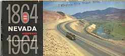
1864-1964 Nevada Highways/Nevada Highways State Of Nevada Department Of Highways 1963-64 State Of Nevada Department Highways 18" x 31-1/2" colorful map of Nevada entitled *1963-1964 Official Highway Map Of Nevada,* includes a mileage chart, and *"National … $25.00
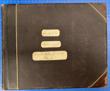
1899 Photograph Album From The Atlantic To The Pacific; Volume 3. Covering California, Utah, … BARKER, C.B. & EVA BARKER 11 x 13 1/2" x 1 1/2," bound in brown heavy pebble-surface cloth, leather corners & spine, with gilt line-and-scroll … $3,500.00
1904 Railroad Map Of Ohio, Published By The State MORRIS, J.C., COMMISSIONER OF RAILROADS AND TELEGRAPHS, COLUMBUS, OHIO] *Map is prepared under the direction of J.C. Morris, Commissioner of Railroads and Telegraphs, Columbus, Ohio.* 28 1/2" x 32 … $750.00
1933 Highway Map Of The State Of Wyoming WYOMING STATE HIGHWAY DEPARTMENT A 49 cm x 61 cm [19 1/4" x 24"] printed in color on a one sheet of 51 cm … $285.00
1936 Highway Map Of The State Of Wyoming CHEYENNE WYOMING STATE HIGHWAY DEPARTMENT A large 20" x 29 1/2" colored map of Wyoming, compiled, drawn and revised by Julius Muller, that folds to … $875.00
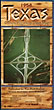
1954 Texas Official Highway Travel Map Texas Highway Department 27 3/4" x 36" sheet folded to 24 panels. 2 $75.00
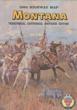
1964 Highway Map Of Montana. Territorial Centennial Souvenir Edition. BABCOCK, TIM [GOVERNOR]. First edition. 8vo. Colored 19 1/2" x 36" sheet, 12 folded panels, illustrated. Front two color panels are of Charles … $25.00
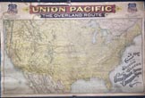
A Correct Map Of The United States Showing The Union Pacific Railroad, The Overland … UNION PACIFIC RAILROAD COMPANY Oblong atlas folio. 37 x 56 in. One large color lithograph map mounted on linen, showing the routes of the … $1,875.00
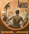
America: Beauty - Wonders - Inspiration - Progress - Without End CANADA AND MEXICO RAILROADS OF THE UNITED STATES First edition. Contains a pictorial full-color map [25 1/2" x 30 3/8"] on a single sheet [26 3/4" x 31 … $495.00
A New Map Of Louisiana With Its Canals, Roads & Distances From Place To … CHARLES DESILVER First edition. 14 5/8" x 17 3/4" color map of Louisiana with a 4 1/2" x 5" color inset map … $1,275.00
A New Route From Europe To The Interior Of North America, With A Description … Canada-North America First edition. Printed wrappers, 19pp. Large colored folding map - 32.5"W x 17.5"H. "Issued by the Nelson Valley Railway and … $500.00
A Ride Up The Glen By Steam. A Mountain Ride By Gravity. Mt Penn … C. M. DECHANT A fascinating broadside with map promoting trips by rail up Mount Penn, whose summit boasted scenic views and entertainment such … $1,200.00
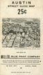
Austin Street Guide Map MILLER BLUE PRINT COMPANY First edition. 22" x 17" one sheet, folds to 7 1/4" x 4 1/4." One side is a street map … $175.00
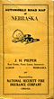
Automobile Road Map Of Nebraska Produced By J.H. Pieper, Albion, Nebraska 20 1/2" x 27 1/2" map folded to 24 panels and enclosed in 7 1/4" x 4" stiff yellow printed … $150.00
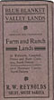
Blue Blanket Valley Lands. Improved And Unimproved Farm And Ranch Lands In Walworth, Campbell, … R.W. REYNOLDS 22" x 16 1/2" sheet with map of South Dakota, heavy red outlining, shows counties, Indian reservations, Chicago, Milwaukee & … $375.00
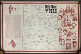
Broadside - Wild West Map Of Utah JAMES H. BECKSTEAD Map of Utah 63.5 x 122 cm [25" x 48"] printed in red and black ink. Map of Utah that … $475.00
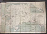
Bruce's Map Of Alaska M. W. BRUCE First pocket map edition of Bruce's popular 24" x 36" color map of Alaska that folds into a 4 1/4" … $575.00
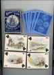
California Midwinter Exposition World's Fair Playing Cards GRAHAM, CHARLES S. [ARTIST] A collection of fifty-three 2.5" x 3.5" playing cards with color chromolithograph images on rectos, seals of California, Oregon & … $650.00
California-Nevada Pictorial Road Map Union Oil Company First edition thus. 19 1/2" x 32 1/4" sheet folded to 9 3/4" x 4 1/2." Double-sided color lithograph maps. … $125.00
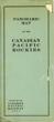
Canadian Rockies Showing Main Line Of Canadian Pacific Railway With Branch Lines & Steamship … CANADIAN PACIFIC RAILWAY A lovely color pictorial map (17" x 45.5", folding to 8.5" x 4") and showing the route of the Canadian … $400.00
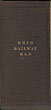
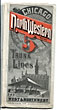
Chicago And Northwestern Railway. Comprising 5 Trunk Lines Chicago And Northwestern Railway 16" x 46 1/2" sheet folded to 50 panels. Printed in red and black. Map. 23 panels of time tables; … $850.00
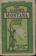
Clason's Montana Green Guide. Showing All The Best Roads. State And City Maps, Auto … GEORGE S. CLASON First edition. 4" x 6 1/2" pictorial wrappers, 48 pp., illustrated, map. Provides comments and suggestions for travel, sight-seeing, cities … $55.00
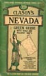
Clason's Nevada Green Guide THE CLASON MAP COMPANY 6 1/4" x 4" green pictorial stiff wrappers printed in black,16 pp., index to Nevada towns, state and city maps, … $175.00
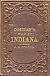
Colton's Map Of Indiana J. H COLTON Original Cloth. Full-color engraved map drawn by George W. Colton and engraved by J. M. Atwood, colored by hand, scrollwork … $975.00
Colton's Map Of Louisiana J. H. COLTON Folding map, 32 x 40 cm [12 5/8" x 15 3/4"] bound-into original decoratively embossed red cloth boards with title … $2,250.00
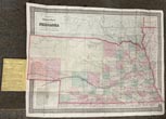
Colton's Township Map Of The State Of Nebraska Drawn, Engraved And Published By G. … G. W. & C. B. COLTON & CO. Folding map 45.3 x 59 cm [17 7/8" x 23 1/4"] affixed to rear inside original blind-stamped, cloth binder with … $2,250.00
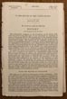
[Committee On The Pacific Railroad] Report... W.M. STEWART First Edition. Disbound. 31pp. Large Folding Map. 27.5"x14". 40th Congress, 3rd Session. Senate. Rep. Com. No. 219. A detailed response … $700.00
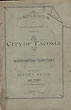
Compendium Of Information Concerning The City Of Tacoma And Washington Territory ALLEN C. MASON Second edition. 8vo. Original printed light green wrappers, 110 pp., frontispiece of map and home of Allen C. Mason. Scarce … $1,300.00
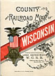
County And Railroad Map Of Wisconsin Wisconsin Central Railroad 5 1/2" x 4" printed folder with map of the United States on the rear cover. Inside front cover offers … $395.00
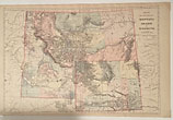
County And Township Map: Montana, Idaho, And Wyoming An attractive, very detailed, hand-colored map. 21.25" x 14.5." Scale 42 miles = 1." Also shows bordering portions of British … $395.00