The Matthews-Northrup Up-To-Date Map Of The United States. Annotated Vest-Pocket Series THE MATTHEWS-NORTHRUP CO First edition. Printed stiff wrappers. Full-color map of United States, with inset map of Alaska, opens to 12" x 20". … $250.00
The New Orleans Tourist's Guide Streckfus Steamer "Capitol" 9" x 8" sheet folded to 4 panels of which two are cover panels. Front cover panel is bright color … $65.00
The Official Guide To The Klondyke Country And The Gold Fields Of Alaska. With … W. B. CONKEY COMPANY First edition. 8vo. Color pictorial wrappers, 296 pp., publishers' notice, frontispiece (pictures on both sides), index, maps, illustrated, portraits. Details … $750.00
The Port Of New York Authority Railroad Terminal Map Of New York Harbor. 38" x 49" color lithographed map, the legend indicating railroads, terminals and yards, waterfront terminals, Railroad passenger stations, free lighterage … $325.00
The Port Of Portland. Portland, Oregon. United States Of America / (Title Page) The … The Port Of Portland Commission First edition thus. 8" x 5" in gray cloth with printed borders and title in black on front cover. 16 … $595.00
The Rand-Mcnally Indexed County And Railroad Pocket Map And Shippers' Guide To Texas Showing … RAND MCNALLY & COMPANY First edition. 12mo. 6 1/2" x 4" brown stiff, printed wrappers, 102 pp., illustrated, advertisements, large color folding map. Large … $875.00
The Rand-Mcnally Vest Pocket Map Of New York City. 3 3/4" x 6 1/4." Stiff grey wrappers, black lettering on covers, n.p., large folding map of New York City … $75.00
The Rand-Mcnally Vest Pocket Map Of Washington. Railroads And Electric Lines, Counties, Congressional Townships, … RAND MCNALLY AND COMPANY First edition. 6 1/2" x 4" printed gray folder, n. p. [4 pp.], advertisements, 20" x 27" color folded map … $575.00
The Standard Road And Railroad Map Of The Beautiful Bermuda Islands EUPHEMIA YOUNG BELL 6 1/8" x 4" printed blue cover, housing a 17" x 19" map entitled, "Map of The Bermuda Islands Alias … $245.00
The St. Augustine Route FLORIDA EAST COAST LINES 13" x 19 1/2" sheet, 24 panels, illustrated, map. One side contains a 3-panel map of Florida and the St. … $350.00
The Texas Pacific Railway. The Short Line From Texas, Mexico And California To St. … Texas & Pacific Railway 17" x 36" sheet folded to 36 panels. Two cover panels, printed in black and red on blue panels. 12 … $1,500.00
The Water-Power Of Maine WALTER WELLS First edition. 8vo, in original brown cloth with title in gilt on spine. vii, [1], 526 pp. Preface. Table of … $375.00
Trails Made And Routes Used By The Fourth United States Cavalry Under Command Of … E. D.--PREPARER DORCHESTER Large Folding Map. 38.5" x 35.5". Scale: 1 Inch=23.76 Miles. "Compiled from military and other surveys; prepared by E. D. … $4,000.00
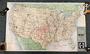
Trans-Continental Territorial Rate Group Map Of The United States TOPEKA AND SANTA FE RAILWAY SYSTEM THE ATCHISON First edition. 48. 5 x 80 cm [19 7/8" x 31 1/2"] full color map on a 51 x 81 … $125.00
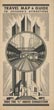
Travel Map & Guide To Chicago's Attractions - Fide The "L" Above Conestion Rapid Transit Lines *1933 Chicago map for Century of Progress.* 21" x 13 3/4" sheet folded to 24 panels. Travel map of Chicago … $175.00
Tulip Time Map Guide FRED S. BERTSCH Nice 17" x 22 1/2" [folds to 8 1/2" x 11"]. Pictorial map of Holland, Michigan, Tulip Festival. Reverse contains … $275.00
Unused Postcard - Idaho Russet Potatoes. World's Finest First edition. 3 3/4" x 6 7/8" shaped potato that opens to 7 1/4" x 6 7/8." Potato opens to … $65.00
U. S. Coast Survey. Map Of Reconnaissance Of Tampa Bay, Florida By The Hydrographic … LIEUT O. H BERRYMAN 24 1/2" x 19 1/4" black and white survey map of Tampa Bay, Florida, folds to 7 9/16" x 11 … $225.00
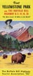
Visit Yellowstone Park Via The Buffalo Bill Highway U.S. 14, 16, 20. "The Most … The Buffalo Bill Highway Tourist Association 16" x 9" sheet folded to 8 panels. All panels are printed in color. Cover panel offers illustration of Wyoming … $175.00
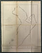
Voyages From Montreal, On The River St. Laurence, Through The Continent Of North America, … ALEXANDER MACKENZIE First edition. Full Leather, early 19th century binding, decorative endpapers, viii, cxxxii, 412,[2]pp. plus 3 folding maps, half-title, frontispiece portrait. … $6,000.00
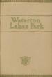
Waterton Lakes National Park, Alberta, Canada M. B. WILLIAMS First edition. Printed wrappers. 45 pp. Place names and altitudes. Folding map at rear, 13.25" x 7.25." Thirty-five attractive black … $75.00
Western Ontario And The American Frontier FRED LANDON First edition. Cloth, 305 pp., color map on endpapers. 2 other maps. A thorough examination of the history of the … $75.00
Western Wayfaring, Routes Of Exploration And Trade In The American Southwest J. GREGG LAYNE First Edition.One of 100 Copies produced specifically for the Zamorano Club. Illustrated Boards with Cloth spine. 63pp. Illustrated with 28 … $200.00
Williams Map Of N. York WILLIAM WILLIAMS Engraved by V. Balch & C. Stiles. Folded 28 1/2" x 20 1/8" colored map housed in 3 1/4" x … $395.00
Yellowstone National Park. "The Cody Road." Direct To The Park Burlington Route 9" x 8 1/2" with colorful pictorial wrapper, folded at center. 24 pp. including wrappers. Maps. Illustrations. Schedules. Double-column text. … $175.00