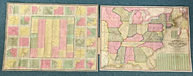
Message From The President Of The United States, Transmitting A Communication From The Secretary … CHESTER A ARTHUR First Edition. Disbound. 4pp.+ Large Folding Map. 47th Congress, 1st Session. Senate. Ex. Doc. No. 121. An interesting report. The … $325.00
Mitchell's National Map Of The American Republic Or United States Of North America SAMUEL AUGUSTUS MITCHELL First edition. 11 x 18.2 cm original roan folder with titles and decorations stamped in gold gilt on the front … $4,250.00
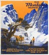
Montana Highway Map. 1941 Montana State Highway Commission First edition. 20 1/2" x 28" sheet, folded to 30 panels. 15 panels offer a map of the Montana State … $85.00
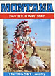
Montana. The Big Sky Country. 1969 Highway Map Montana State Highway Commission 36" x 19 1/4" sheet folded to 24 panels. 2 bright, colorful cover panels, 1 panel with a welcome by … $15.00
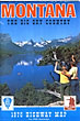
Montana. The Big Sky Country. 1970 Highway Map Montana State Highway Commission 35 1/2" x 18" sheet folded to 24 panels. 2 bright, colorful cover panels, 1 panel with general information about … $15.00
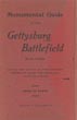
Monumental Guide To The Gettysburg Battlefield With Index Showing The Location Of Every Monument … HAMMOND, SCHUYLER A.; HEWITT, EDGAR M. (MAP B Y) 6 7/8" x 4 1/4" red carboard wrappers containing a 31 1/2" xc 23 1/2" folded black and white map. … $600.00
Mormon Trail J. RULON HALES First edition. 20 1/2" x 30" sheet printed in yellow, orange and black. A charming pictorial Mormon trail route map, … $475.00
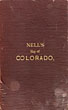
Nell's Map Of Colorado LOUIS NELL First edition. 11.6 x 18.5 cm [4 9/16" x 7 1/4"] cloth folder with titles stamped in gold gilt on … $1,500.00
Nevada. Standard Oil Road Map Standard Oil Company Of California 28" x 24" sheet, folded to 24 panels. 2 bright colorful cover panels showing a woman at the wheel of … $75.00
New Castle County Delaware. 16 1/4" X 21" Matted & Framed Colored Broadside Sheet. VERNON GOOD 16 1/4" x 21" single broadside sheet. Full color print reproducing Vernon Good's collage of over thirty views of old … $350.00
New Light On The Early History Of The Greater Northwest, The Manuscript Journals Of … COUES, ELLIOTT [EDITOR]. First edition. *3 Volumes.* Limited to an edition of 1100 copies, 1000 of which are printed on smaller paper. This … $1,275.00
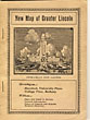
New Map Of Greater Lincoln. Map Large, folding map. 25" wide x 28" high. Affixed to inside of rear wrapper. Stiff printed wrappers, 120pp., profusely illustrated. … $100.00
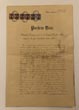
Original Title To The "El Dorado" Gold Mine Located In The Municipal Area Of … DIAZ, PORFIRIO-PRESIDENT & SIGNATORY 11.5"x17". Printed on a heavy grade of paper. An original document, executed and signed by Mexican President Porfirio Diaz, giving … $1,750.00
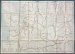
Parts Of Western Wyoming, Southeastern Idaho And Northeastern Utah F.V HAYDEN Large Folding Map. 32.5" x 22.5". U.S. Geological And Geographical Survey Of The Territories, F. V. Hayden, U.S. Geologist In … $350.00
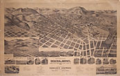
Perspective Map Of The City Of Helena, Mont. Capital Of State, County Seat Of … KESSLER'S BREWERY 26 1/2" X 39 1/2" perspective map of Helena, Montana. Mounted on cardboard the map displays a birds-eye overview of … $1,395.00
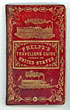
Phelp's Travelers' Guide Through The United States; Containing Upward Of Seven Hundred Rail-Road, Canal, … HUMPHREY PHELPS First edition. 16mo. Pictorial gilt-stamped red leather covers with ornate gold borders and gold pictorials of a steam locomotive and … $1,295.00
Railroad Commissioners' Map Of Washington 1907. Washington Railroad Commission 34" x 47 1/2" sheet folded to 6" x 8 3/4" featuring a partially colored map of Washington with a … $650.00
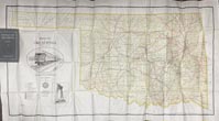
Railroad Map Of Oklahoma Published By The State. Prepared Under The Direction Of Corporation … Corporation Commission Of Oklahoma *Map is compiled and drawn by the Engineering Department Corporation Commission.* 53" x 27" folded railroad map of Oklahoma. Colored … $1,500.00
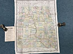
Rand, Mcnally & Co.'S Dakota Territory Map Rand Mcnally & Company 26" x 20 1/4" hand-tinted map of Dakota Territory showing Indian reservations, forts and railroads. Light wear, light creasing, age-toning … $850.00
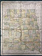
Rand, Mcnally & Co's Indexed County And Township Map Of Dakota With A New … RAND, MCNALLY & COMPANY Large 26 1/2" x 20 1/2 " full-color folding map of Dakota Territory that details all locations of railroads, counties, … $750.00
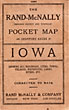
Rand Mcnally & Co.'S Indexed County And Township Pocket Map And Shippers' Guide Of … RAND MCNALLY & COMPANY First edition. 6 1/2" x 4" stiff printed wrappers, 50 pp., including advertisements for hotels, color map. Folded color map … $250.00
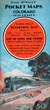
Rand Mcnally Pocket Maps Of Colorado For Tourists, Travelers, Shippers, General Commercial And Business … RAND MCNALLY & COMPANY Edition 1942. 8vo. 9 1/4" x 4 1/4" color pictorial wrappers, 32 pp., large folding map. The folding map is … $525.00
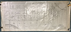
Right-Of-Way And Track Map/Station Map - Lands THE UNION TERMINAL COMPANY Two 60" x 27" black and white maps of Downtown Dallas, Texas, showing the area just north of the Trinity … $2,750.00
Road Map Of Utah State Road Commission Of Utah 28" x 22 3/4" sheet folded to 36 panels. 18 panels offers a road map of Utah and with legend. … $175.00
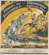
Roads To Romance. Montana Highway Map. 1940 Montana State Highway Commission First edition. 20 1/2" x 28" sheet, folded to 30 panels. 15 panels offer a map of the Montana State … $85.00
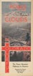
Roads To The Clouds In Colorado THE COLORADO ASSOCIATION First edition. 8vo. 9" x 16" one sheet that folds to 9" x 4." Four panels per side. One side … $275.00
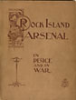
Rock Island Arsenal: In Peace And In War. With Maps And Illustrations BENJAMIN FRANKLIN TILLINGHAST 9-1/2" x 7-1/4" printed wrappers with a map of the Illinois & Mississippi Canal on the back cover. [xxxii]. Advertisements … $350.00
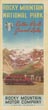
Rocky Mountain National Park, Estes Park, Grand Lake ROCKY MOUNTAIN MOTOR COMPANY Single sheet (18" x 16") folds to 9" x 4," printed on two sides. One side prints a pictorial map … $125.00
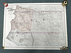
Sectional Map Of Colfax And Mora Counties, New Mexico EDWARD ROLLANDET First edition. 28 3/4" x 39 1/4" colored lithographic map, printed on banknote paper. An attractive and finely-executed map of … $750.00
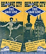
Seeing Salt Lake City GRAY LINE MOTOR TOURS Single sheet [47 cm x 40 cm] that folds to pamphlet [23.5 cm x 10 cm]. Printed in yellow, blue … $125.00