
Dealer in Rare and First-Edition Books: Western Americana; Mystery, Detective, and Espionage Fiction
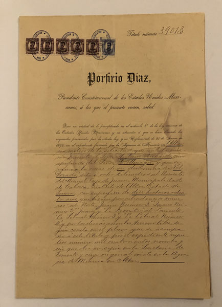
Original Title To The "El Dorado" Gold Mine Located In The Municipal Area Of Caborca, District Of Altar, State Of Sonora, Mexico.
DIAZ, PORFIRIO-PRESIDENT & SIGNATORY
Other works by DIAZ, PORFIRIO-PRESIDENT & SIGNATORYPublication: Palace of the Federal Government, 1907, Mexico City
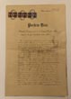
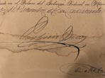
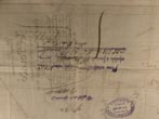
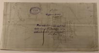
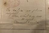
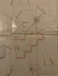
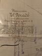
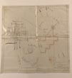
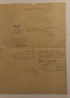
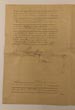
11.5"x17". Printed on a heavy grade of paper. An original document, executed and signed by Mexican President Porfirio Diaz, giving title to a gold mine entitled "El Dorado", the size being 10 hectares and 80 ares (approximately 26.7 acres), located in the Municipal area of Caborca, District of Altar, State of Sonora, Mexico. It is described as having contiguous boundaries with the following existing mines: To the North, "Juarez Numero 3", "Juarez Numero 2", "Juarez", and "La Favorita"; and to the West, "La Liberal Numero 3" and 'La Liberal Numero 4". Of the inside pages of the document, the left page again describes the location of the mine and the name of the owner, in language in which Diaz "presents" and "orders" and requests support from all capable of providing support for this enterprise, and is boldly signed by Porfirio Diaz, "in the Palace of the Federal Government in Mexico (City), the nineteen of December of one thousand nine hundred seven." The second and third pages contain 3 stamps and numerous signatures from various individuals and agencies, one of which shows Public Registration of this title on January 27, 1908. The document is a printed form, with the form printed in a brown calligraphic script. The printed form portion of the document comprises about 25% of the content of the first page, 50% of the content of the second page, and 10% of the content of the third page. Everything else is handwritten in brown ink, in an attractive, highly-legible script. Equally as important, and perhaps more unique, this document includes a large, hand-drawn Plan/Map of the gold mine "El Dorado". 16.5"x16.5", with a detailed description of the location and size of the mine written neatly in brown ink by a professional calligrapher, and signed by an official in Altar, Sonora on January 17,1907, with his stamp.The central portion of the Plan/Map shows the dimensions of "El Dorado" and it's proximity to several existing gold mines as listed above, plus "La Liberal" and "La Liberal Numero 2. Every mine is neatly labeled by hand in brown ink. The boundary specific to "El Dorado" is in red ink and gives every measure in meters. Also the perimeter of all "La Liberal" mines is in yellow. In the lower right portion of the Plan/Map, neatly hand-written in brown ink confirms that this an original pen copy, attested to by Manuel Pesqueira, in Altar, April 4, 1907. On the verso of the Plan/Map are 3 different stamps, each signed and/or completed by hand and dated December 19,1907. The document has 1 horizontal fold. The Plan/Map, due to it's size has 1 horizontal and1 vertical fold. The Plan/Map is printed on a thin, fiber-reinforced paper. The location of "El Dorado" is in northern Sonora, Mexico, approximately 80 miles southwest of Nogales, Arizona. There is minor dampstaining across the center of the first and second page and along the lower fore-edge, although not affecting the printing. Light occasional wear to edges, else in great condition for an original document of it's age. The Plan/Map is in exceptionally nice condition. Complete English translation laid-in.
Inventory Number: 51509
$1,750.00


![Texas And The Gulf Of Mexico; Or, Yachting In The New World. HOUSTOUN, MATILDA CHARLOTTE (JESSE) FRASER [EDITED WITH AN INTRODUCTION BY MARILYN MCADAMS SIBLEY]](/media/images/thumb/49478.jpg)

