Dealer in Rare and First-Edition Books: Western Americana; Mystery, Detective, and Espionage Fiction
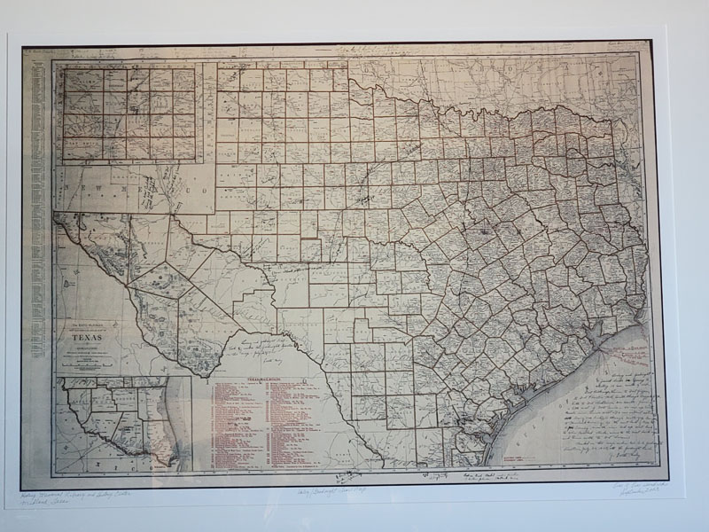
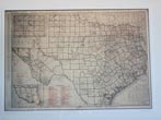
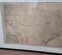
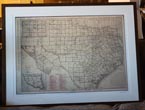
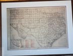
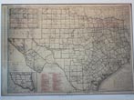
Haley-Goodnight Map
J. EVETTS HALEY
Other works by J. EVETTS HALEYPublication: Rand McNally, n d (ca 1920s), Chicago, 2003
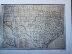
Charles Goodnight, Cowman and Plainsman is considered the best biography of a cattleman ever written. This is because of J. Evetts Haley’s extensive interviews with Goodnight. In 1925, Haley sat down with the then 90-year-old and, using the map above, drew at Goodnight’s direction, the route of the Goodnight Trail from Young County to Fort Sumner. The route is best described in Haley’s handwritten note at the bottom right-hand corner of the map which reads: "Loving and Goodnight joined herds in Young County, starting 12 miles south of old Fort Belknap, thence to Fort Griffin to Fort Phantom Hill. South through Buffalo Gap, S. W. to Fort Chadbourne, on south, passing a little west of Fort Concho--- 40 miles up South Concho River, then West---- (96 mi. without water and losing 300 head)---- through Castle Gap Canyon to Horsehead Crossing. Up the west bank of the Pecos to Polk’s Crossing, across the river and up west bank to where Carlsbad stands, across to the east bank again and thence north to Fort Sumner. Marked on this map under Col. C. C. Goodnight’s direction, July 24, 1925, at the Goodnight Ranch." J. Evetts Haley (signed) Noted on the map are "7 mi. below Carlsbad, Loving had his fight with the Indians" and the 96-mile stretch without water. Later the Chisholm Trail was marked by Haley under the direction of Arthur Johnson of Midland. Across the top margin of the map, all in Haley’s handwriting, are brands of 25 Texas ranches--- the JA, LX, LIT, and Rocking Chair to name a few,--- and the county in which they were located. The map, in tatters, was discovered in the library’s archives and taken to J. "Pat" McDaniel, the executive director. Realizing its importance, McDaniel suggested to the board of trustee that they authorized the restoration and reproduction of the map. For a humorous account of the map’s restoration and the story of Loving and Goodnight’s drive to Fort Sumner, go to www.YouTube.com and enter "Goodnight Haley Trail" to hear board member Bill Caruth’s entertaining account (note: former students of Texas A&M may want to skip this). After the map was restored, the Library printed one hundred copies, all numbered "1 of 100, September 2003." These were then sold to raise money for the Library's endowment fund. Map details: Printed on archival paper, matted and framed. Overall dimensions: 50" x 38." Map & mat: 27 1/2" x 40." Map size (measured to the neat line): 26" x 37 1/2." Rand McNally’s New Commercial Atlas Map of Texas, n.d. [1920s]. Condition: Fully restored to near fine condition. Also shows railroads (including ones under construction), identifies county seats, principal cities, and the state capital. Matted, framed, behind glass, and ready to hang on a wall, it ready to be a focal point for an office, board room, study, or den. Limited to only 100 copies, I found none on-line or in auction records.
Inventory Number: 51004
$4,500.00
![Amphibians And Reptiles Of The Us-Mexico Border States. [Anfibios Y Reptiles De Los Estados De La Frontera Mexico-Estados Unidos] LEMOS-ESPINAL, JULIO A. [EDITED BY]](/media/images/thumb/40213.jpg)