Dealer in Rare and First-Edition Books: Western Americana; Mystery, Detective, and Espionage Fiction
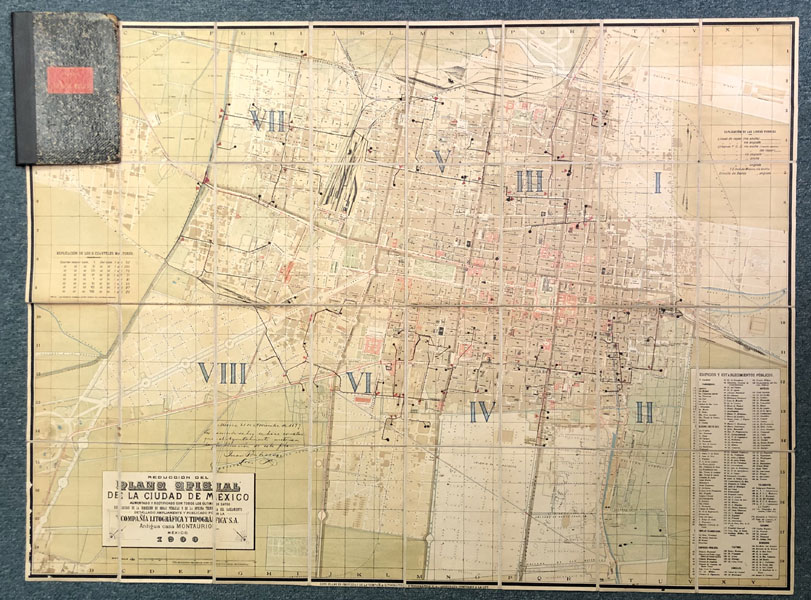
Reduccion Del Plano Oficial De La Ciudad De Mexico. Aumentado Y Rectificado Con Tados Lo Ultimos Datos Recogidos De La Direccion De Obras Publicas Y De La Oficina Tecnica Del Saneamiento
S. A. COMPANIA LITOGRAFICA TIPOGRAFICA
Other works by S. A. COMPANIA LITOGRAFICA TIPOGRAFICAPublication: Compania Litografica Tipografica, S A 1900, Mexico City
30.5 x 41 inches, mounted on linen and dissected into 32 sections, folding into marbled boards with mounted label. A highly detailed map of Mexico City in 1900. In addition to the full identification of streets and rail lines, the key includes 194 sites, including dozens of churches and cathedrals, shops and markets, telegraph offices, hotels, theaters, and public buildings. A scarce map offering a comprehensive view of Mexico City at a time when modern systems of transportation and communication were just being developed. Highly detailed map is in very good condition and the binder has reinforcement to the spine and a bit of cosmetic repair to the corners and fore-edges. Overall a very solid item.
Inventory Number: 46028Sold -- Contact us