Dealer in Rare and First-Edition Books: Western Americana; Mystery, Detective, and Espionage Fiction

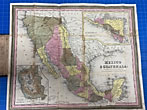
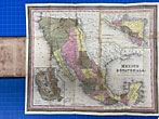
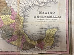
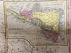
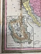
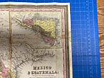
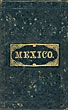
Mexico & Guatemala Map
SAMUEL MITCHELL
Other works by SAMUEL MITCHELLPublication: Published by S Augustus Mitchell, 1846, Philadelphia
First edition and issue of this noted map issued on the brink of the Mexican-American War. Colorful folding map 30.5 x 37.5 cm. [12" x 14 7/8"] folded into original boards with title stamped in gilt on the front cover. Scale is about 200 miles to the inch. Later issues of this map would depict battle flags. Guatemala is an inset and there is also an inset of the Valley of Mexico. Texas extends into present day New Mexico, a smaller portion of New Mexico shown with a large Sonora and Sinaloa. Upper and Lower California towns located on the Pacific Ocean. After the Mexican-American War, this region would become the American Southwest. Minor staining to some folds but not distracting for an overall very good condition. Not in Phillips or Garrett.
Inventory Number: 48474Sold -- Contact us
![Annual Report Of The Secretary Of War For The Year 1886. Volume I. ENDICOTT, WILLIAM C. [SECRETARY OF WAR].](/media/images/thumb/53657.jpg)