Dealer in Rare and First-Edition Books: Western Americana; Mystery, Detective, and Espionage Fiction

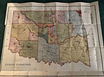
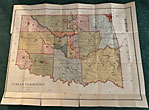
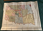
Indian Territory.
Map - Indian Territory
Other works by Map - Indian TerritoryPublication: Julius Bien & Co, 1885, New York
Issued by the Department of the Interior, General Land Office, N.C. McFarland, Commissioner. First Issue. Large, folding color map. 31.875" x 23.875" + .5-1.5" plain border. An exceptionally bright, colorful map. A rather large scale of: 12 miles to 1 inch. This is a detailed map of the Indian Territory naming towns, rivers, creeks, mountains, hills, and many other physical features. Roads and trails are shown, including stage stations. A highly-uncommon feature of this map are the appearance of 4 cattle trails: Abilene Cattle Trail, Shawnee Cattle Trail, Texas Cattle Trail, and Chisholm's Cattle Trail. Prominently featured are the primary Military Forts: Ft. Supply, Ft. Sill, Ft. Reno, and Ft. Gibson; as well as other smaller forts: Ft. Arbuckle, Ft. McCullock, Ft. Washita, Ft. Cobb, Old Camp Augur, and Ft. Smith. The primary features of this map is its identification of each Indian reservation in the Indian Territory. Each reservation is a different color and identifies the tribe or tribes that occupy each reservation. The various tribes and reservations identified are: Cherokee, Creek, Choctaw, Chickasaw, Seminole, Osage, Kansas, Nez Perce, Ponca, Otoe, Missouria, Pawnee, Iowa, Sac and Fox, Kickapoo, Pottawatomies, Cheyenne, Arrapaho, Wichita, Kiowa, Comanche, Apache; Quapaw, Peoria, Ottawa, Shawnee, Modoc, Wyandotte, Seneca, and Oklahoma. The agencies and missions associated with some tribes are shown. Railroad lines are a prominent feature in the eastern portion of the map. The Missouri Pacific or Missouri, Kansas, & Texas Railroad is shown crossing the territory, north and south. From the northeast corner, southwesternly the St. Louis & San Francisco Railroad runs through Tulsa, and just beyond to Red Fork. Also shown is an apparent projected future route for a "Branch Line of the A & P RR" following the course of the Canadian River from Ft. Smith westward across the territory. This beautiful map was: "Compiled from the Official Records of the General Land Office and Other Sources. G.P. Strum, Principal Draftsman G.L.O., and Photo Lith & Print by Julius Bien & Co., 139 Duane St., N.Y." Printed along lower left edge of plain border is indicated the following: "S. Ex. 50, 2, 48. A large, clean, bright map in exceptionally nice condition. A few short splits in the blank margin and very short splits at a couple of intersections of folds. Near fine.
Inventory Number: 47704Sold -- Contact us