Dealer in Rare and First-Edition Books: Western Americana; Mystery, Detective, and Espionage Fiction
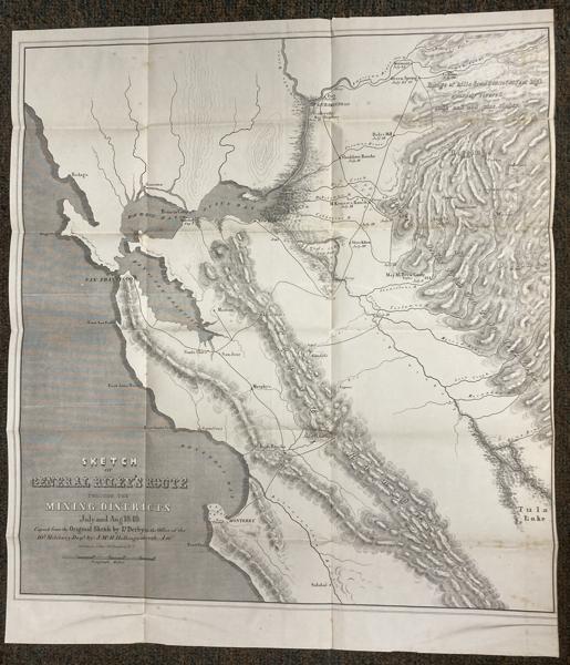
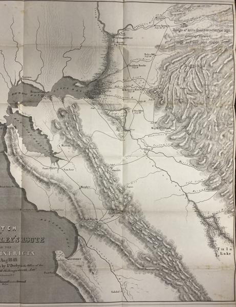
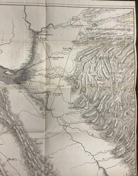
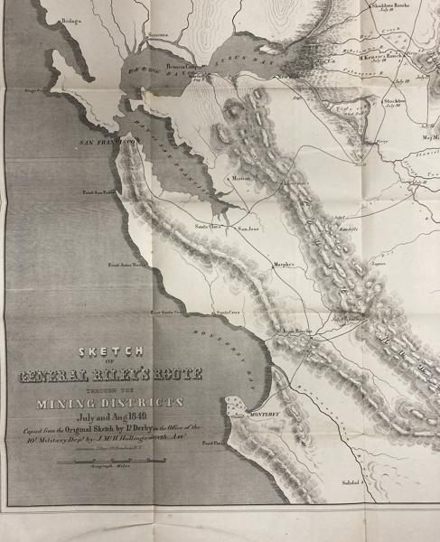
Sketch Of General Riley's Route Through The Mining Districts July And August 1849
LT. GEORGE HORATIO DERBY
Other works by LT. GEORGE HORATIO DERBYPublication: Government printing office, 1850, Washington
First edition. Map measures 20 1/2" x 19 1/4" with title in the lower left corner. A lithograph map of Northern California from just south of Monterey to just north of Sacramento and from the Pacific Ocean to the Sierra foothills; Showing General Bennet Riley's route through the mining districts with dates visiting the mining camps in the Sierra foothills. In 1850, this was an important and, at the time, a highly desirable map of California Gold Rush diggings. The map was part of the Senate and House reports of Brev Brig Gen. Bennet Riley dated at Monterey on September 20, 1849 entitled "Report of a Reconnaissance of a Portion of the San Joaquin and Sacramento Valleys". (From Wheat). The map provides the earliest names and location of the mining camps and diggings in the central Sierra foothills along the American, Cosumne, Dry Creek, Mokelumne, Calaveras, Stanislaus, Tuolumne, Merced, Lost Creek, Maraposa [sic] and King rivers of the Central Valley draining to the San Joaquin river. The more populated camps were Mormon Island (misspelled Mormont), Coloma (mislabeled Colluma), Curtis, Sullivan's, Jamestown, Woods, Maj. Miller's and Sonoran Camps. Lt. Derby provides topographical and travel conditions along the routes with ates and details in the geography, terrain and communities. General Bennet Riley (1787-1853) was the 6th and last Military Governor of California in 1849. He ordered four surveys of California to be lead by Lt. George Derby (1823-1861). From Wheat, "... George Horatio Derby (1823-1861), born at Dedham, Massachusetts, April 2, 1823, graduated from West Point in 1846, and after a tour of duty in the East and Middle West, came to California in 1849. He accompanied Brig Genl. Riley on a tour of the gold districts during the summer of that year, and his `Sketch of General Riley's Route' was the result of that journey." George Horatio Derby (1823-1861) also known as John Phoenix or John P. Squibob or just Squibob, was an 1846 West Point graduate. As a Lt. in the U.S. Army Corps of Topographical Engineers, he , participated in the Mexican-American war and was assigned to California in 1849. Under General Riley, Military Governor, he explored and mapped of California and Oregon during the early years of the Gold Rush. To supplement his army income, he wrote humorous articles and this book on the irreverent side of California life. The purpose of the 1849 journey was to identify existing settlements and mining camps and determine locations of strategic military supply routes and posts to "... afford protection for and from the Indians and keep the peace among the gold miners." [William H. Goetzmann, Army Exploration in the American West 1803-1863, Yale University Press, 1959, p.255]. This map relates to another important early map of the Sacramento Valley surveyed in September and October 1849 from north of Sacramento City to the Butte River (the second survey ordered by General Riley). A third survey was ordered by General Riley in 1850 to survey the southern Tulares Valley in April and May of 1850. The Map of Reconnaissance of the Tulares Valley was included in the Senate Exec. Doc. No. 110 August 24, 1852. The map is printed on thin paper and the fold creases are evident with minor age toning, outer vertical right neat line trimmed, repaired closed tear at top right edge. a few light foxing spots in upper and lower right. Overall a very good map.
Inventory Number: 52310$975.00