
Dealer in Rare and First-Edition Books: Western Americana; Mystery, Detective, and Espionage Fiction
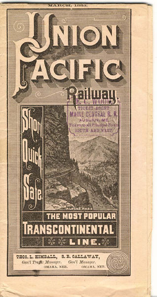
Short, Quick, Safe. The Most Popular Transcontinental Line
Union Pacific Railway
Other works by Union Pacific RailwayPublication: Privately printed, 1885, NP
17" x 44" sheet on peach-colored stock folded to 40 panels each 8.5" x 4.4". Opens to a 20 panel map of the Union Pacific Railway through Kansas and Nebraska and from Colorado, Wyoming, Montana, Utah, Nevada, Idaho, Washington, Oregon and California. This map is colored by time zones. On opposite side are 20 panels of time tables and fares, general passenger information, descriptions of the sleeping cars, information on important connections, etc. Minor wear to the folds and extremities and ticket agent's stamp to front wrapper. All in all, in nice condition.
Inventory Number: 35200Sold -- Contact us

![Asheville, North Carolina. "In The Land Of The Sky." (Cover Title) ASHEVILLE CHAMBER OF COMMERCE [GEORGE MASA, PHOTOGRAPHER]](/media/images/thumb/46666.jpg)

