
Dealer in Rare and First-Edition Books: Western Americana; Mystery, Detective, and Espionage Fiction
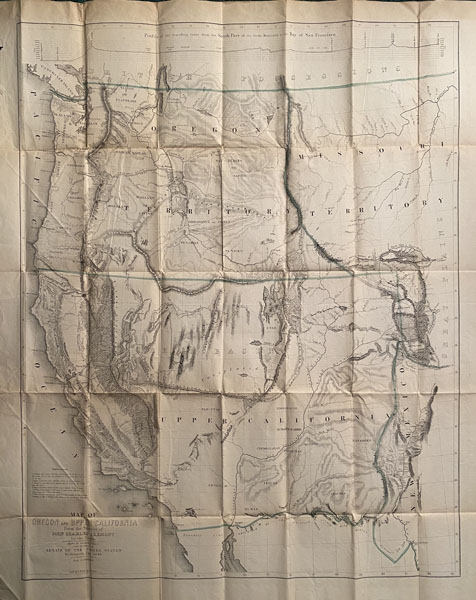
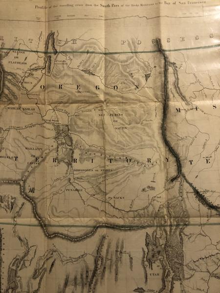
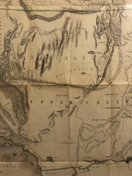
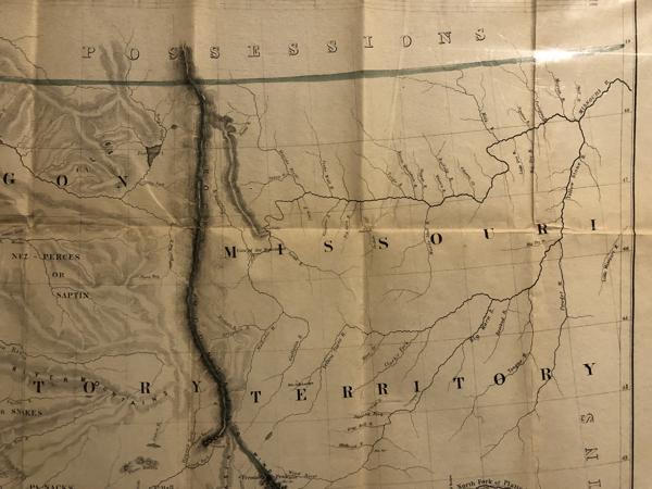
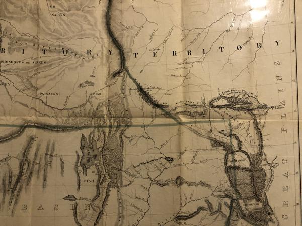
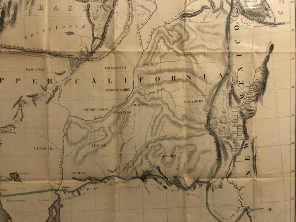
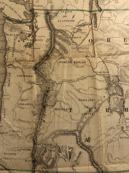
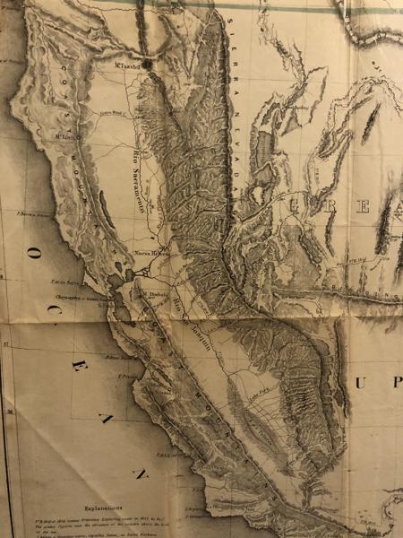
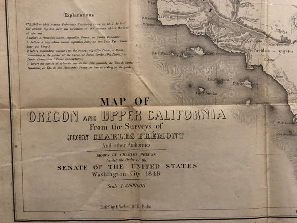
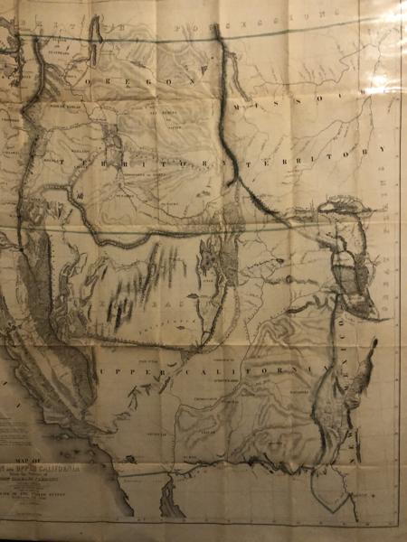
Map Of Oregon And Upper California
Fremont, John Charles
Other works by Fremont, John CharlesPublication: Senate of the United States, 1848, Washington City
Large Folding Map. 29.5" wide x 36" long. From the Surveys of John Charles Fremont and Other Authorities. Drawn by Charles Preuss. Under the order of the Senate of the United States. Washington City 1848. Scale 1:3,000,000. Lith. by E. Weber & Co, Balto. This important map was originally prepared to accompany Fremont's work, GEOGRAPHICAL MEMOIR UPON UPPER CALIFORNIA. Considered by many to be the greatest of Charles Preuss's maps. Preuss accompanied Fremont on his first three expeditions exploring the American West. "The one great general map of 1848 was that of Fremont and Preuss"-Carl I. Wheat, scholar and author of MAPPING THE TRANSMISSISSIPPI WEST. Wheat dedicates 8 pages to his discussion of the importance of this map. It is a map of all the territory of the United States west of the 105 meridian. Accordingly, it presents, in wonderful detail, the American West, from the front line of the Rocky Mountains to the Pacific Ocean. It shows the routes followed by Fremont's various expeditions from 1842 through 1846, and benefits significantly from the exploration of Edward Kern, as part of Fremont's third expedition. The map is the first to show the location of the recent gold discoveries in California, and also is the first to identify the entrance to San Francisco Bay as the Golden Gate. The intent of the map was to attain completeness in its representation of the known cartography of 1848, reflecting the cartographic benefits of Fremont's many expeditions, as well as those of Kern and others. A wonderful map. Our copy is in exceptionally nice condition ... bright, clean, and with no tears or splitting at folds!
Inventory Number: 49403$1,850.00
Related Books
![Souvenir Of Tucson Arizona. The "Old Pueblo." The Sunshine City Of America BLYTHE, T. ROGER [SKETCHED & EDITED BY]](/media/images/thumb/36569.jpg)
![Souvenir Album Of 1891, City Of Denver Colo BARBOT, W. A. [COMPILED BY]](/media/images/thumb/32740.jpg)
![Quantrell's Raid On Lawrence. By L. D. Bailey And Others. With Names Of Victims Of The Raid GREEN, C. R. [EDITOR]](/media/images/thumb/48442.jpg)
![An Outline History Of Transportation BOUTON, ARCHIBALD L. [EDITED BY]](/media/images/thumb/41188.jpg)

