Dealer in Rare and First-Edition Books: Western Americana; Mystery, Detective, and Espionage Fiction
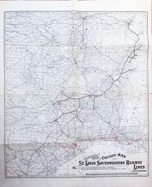
Geographically Correct County Map Of St. Louis Southwestern Railway Lines And Connections
ST. LOUIS SOUTHWESTERN RAILWAY COMPANY
Other works by ST. LOUIS SOUTHWESTERN RAILWAY COMPANYPublication: Poole Bros, n d (ca 1916), Chicago
29 1/2" x 24" folding map.
Scarce, large folding map of railroad lines operated by the St. Louis Southwestern Railway during the 1910s. Highlighted here in bold is the Cotton Belt Route, which ran from St. Louis to Fort Worth, Tyler, and Waco through Texarkana. Printed in red are lines in Texas and Louisiana controlled by or operated in conjunction with the Texas subsidiary of the of the St. Louis Southwestern. The majority of these fan out from Houston, connecting the city with Waco, Tyler, Dallas, San Antonio, Corpus Christi, Shreveport, and New Orleans. We locate three copies of a similar work bearing the publication information of Chicago mapmakers Poole Brothers. The present copy lacks any imprint, but also does not bear signs of having been removed from an atlas or another volume. A detailed delineation of rail travel in Texas and neighboring states circa World War I. Light wear and several short closed tears along right edge. A couple of short separations along folds, light tanning and dust soiling, else very good copy.
Inventory Number: 46277Sold -- Contact us