Dealer in Rare and First-Edition Books: Western Americana; Mystery, Detective, and Espionage Fiction
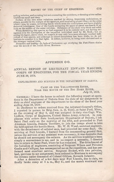
Annual Report Of Lieutenant Edward Maguire, Corps Of Engineers, For The Fiscal Year Ending June 30,1876. Explorations And Surveys In The Department Of Dakota. Camp On The Yellowstone River, Near The Mouth Of The Big Horn River, July 10, 1876.
LIEUTENANT EDWARD MAGUIRE
Other works by LIEUTENANT EDWARD MAGUIREPublication: Government Printing Office, 1876, Washington
First edition. Printed wrappers, pp. 699-704, 16 1/2" x 18" foldout map of the Custer Battlefield. The map was surveyed and drawn under Personal Supervision of Lieutenant Edward Maguire, Corps of Engineers U. S. A. by Sergeant Charles Becker, Co. "D" Battalion of Engineers. Together with the map and six pages of text by Maguire that describes the map and the battle site. This is an important map. The map represents the most contemporary information of the Custer fight. Attached to Terry's command, Maguire was detailed to map the scene of the battle and to bury the dead and burn the material left by the Indians. The markers are placed by Maguire's men at the outlying spots where some of the officers and men fell has been of the utmost importance in interpreting what actually took place on that hot Sunday in June of 1876. Map in fine condition, text in very good condition.
Inventory Number: 45211Sold -- Contact us