Dealer in Rare and First-Edition Books: Western Americana; Mystery, Detective, and Espionage Fiction
![Wonderland 1906. Illustrated. This Number Describes The Yellowstone National Park, A Trip Through The Bitterroot Mountains, Columbia River And Puget Sound Region, The Queniut Indians Of The Northwest Coast, And Gives Some Information About Alaska WHEELER, OLIN D. [NORTHERN PACIFIC RAILWAY]](/media/images/large/37255.jpg)
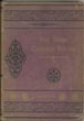
Wonderland 1906. Illustrated. This Number Describes The Yellowstone National Park, A Trip Through The Bitterroot Mountains, Columbia River And Puget Sound Region, The Queniut Indians Of The Northwest Coast, And Gives Some Information About Alaska
WHEELER, OLIN D. [NORTHERN PACIFIC RAILWAY]
Other works by WHEELER, OLIN D.Publication: AM Cleland, 1906, St Paul
9 1/2" x 6 3/4" brown pictorial wrappers. 76 pp., numerous black and white illustrations, frontispiece, 2-page map of the United States depicting the Northern Pacific Yellowstone Park Line and connections. Overview and history of Yellowstone along with information on park improvements, hotels, etc. Discusses the lower, midway and upper geyser basins, the mud "vulcano," the falls, grand "canon," the Bitterroot Mountains, the Columbia River, Puget Sound, and the Alaskan Northland. 7 pages devoted to a day spent with the Queniut Indians. Much information on scenery, history, activities, peoples, etc. One-page map of Yellowstone National Park showing the park transportation roads. Front wrapper faded from burgundy to brown and with chipping to head and toe of spine along with wear to the extremities. Interior lightly soiled and text pages reinforced with archival tape to front and rear wrappers. A very nicely produced booklet, filled with lovely photographs and information.
Inventory Number: 37255Sold -- Contact us