Dealer in Rare and First-Edition Books: Western Americana; Mystery, Detective, and Espionage Fiction
![The Columbia Basin Irrigation Project [With] Ephrata, Washington, Western Gateway To The Columbia Basin And Grand Coulee Projects [With] Columbis Basin Lands--City Property Map, Ephrata, Washington COLUMBIA BASIN PROJECT](/media/images/large/48572.jpg)
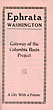
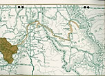
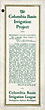
The Columbia Basin Irrigation Project [With] Ephrata, Washington, Western Gateway To The Columbia Basin And Grand Coulee Projects [With] Columbis Basin Lands--City Property Map, Ephrata, Washington
COLUMBIA BASIN PROJECT
Other works by COLUMBIA BASIN PROJECTPublication: Columbia Basin Irrigation League, 1939, Spokane
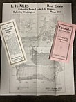
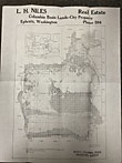
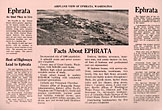
Three items relating to the early history of the Columbia Basin Project (CBP), an immense irrigation development in central Washington State that provides water from the Columbia River to about 670,000 acres on the Columbia Plateau. The first survey of the irrigation potential of the area was conducted in 1922, but the project was not approved until 1943, and water did not begin flowing into canals until 1952. The first item in this grouping (4" x 9", 16 pp + folding map) was published by the Columbia Basin Irrigation League (Spokane) in 1928. It provides optimistic projections of the economic benefits the project will bring via jobs and supplies needed for construction and then purchases made by the farming families who will flourish on the newly irrigated land ("thousands of carloads of lumber, shingles, tarpaper, and other building materials...barbed wire, fence, and fence posts. Immense quantities of clothing, groceries, household furniture--all of the articles concerned in the making and maintenance of farm homes," as well as farming equipment and livestock). It discusses other social and civic benefits of the project, addresses the costs of construction and methods of financing, and argues for Pend Oreille River (rather than the Columbia, which was ultimately selected) as the main water source. The other two items date from ca. 1939, and promote the small central Washington city of Ephrata (then population 1080) on the basis of benefits the CBP is expected to bring. A tri-fold brochure offers typical praise for the town's services and institutions and declares it "the coming city of the Grand Coulee Dam and Columbia Basin Project" and promising that the project "will furnish homes and work for over 100,000 directly and indirectly to thousands more. 40,000 40-acre farms will make a great empire." The final item is a plat map (14" x 18") distributed by Ephrata realtor L.H. Niles that shows which parcels of land fall within the proposed Quincy-Columbia Basin Irrigation District, which surrounds Ephrata. Locations of other towns, roads, and railroads are also shown. Despite early promises of an influx of small, self-sufficient farms, in the end much of the benefit of irrigation went to corporate agribusiness operations. Very good copies.
Inventory Number: 48572Sold -- Contact us
![North, East, South, West. A Regional Anthology Of American Writing. LEE, CHARLES [GENERAL EDITOR].](/media/images/thumb/25174.jpg)