Dealer in Rare and First-Edition Books: Western Americana; Mystery, Detective, and Espionage Fiction
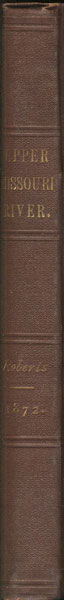
Report Of A Reconnaissance Of The Missouri River In 1872
THOMAS P. ROBERTS
Other works by THOMAS P. ROBERTSPublication: Government Printing Office, 1875, Washington
First edition. Original brown cloth, spine stamped in gilt. "Printed for the use of the Engineer Department, U.S.A." Limited to 250 copies. 56pp. 1 plate. 3 tables. 2 folding charts. 2 folding diagrams. 2 folding maps. 3 very large folding maps described as follows: "Reconnaissance of the Upper Missouri River From Three Forks To Fort Benton, Mon. Ter. 1872." Published by authority of the Hon. Secretary of War, in the Office of the Chief of Engineers, U.S. Army, 1875. In 3 sheets. Scale: 1 inch=1 mile. Map 1: 21.5"W x 46.25"H. Map 2: 21.25"W x 45.5"H. Map 3: 21.375"W x 48.25"H. Three primary maps produced by: The Graphic Co. Photo-Lith. 39 & 41 Park Place, N.Y. Part I of this report is comprised of the following: Journal of Trip Up Missouri River From Sioux City to Fort Benton, Montana; General and Comparative Description of Missouri River; The Present and Future Necessity for the Improvement of the Missouri River; Suggestions Concerning Plans for the Improvement of the Navigation of the Upper Portion of the Missouri River; and the Radical Improvement of the Lower or Sandy Portion of the Missouri river. Part II is a supplementary report "Concerning the Exploration of the Upper Missouri River, viz. between Gallatin City, Mont., or the Three Forks of the Missouri, and Fort Benton, including a partial survey and reconnaissance of the Great Falls, which were examined, in case the upper river proved practicable for steamboats, with reference to a route around them for a narrow-gauge railroad." The very large folding maps are in exceptional condition with minimal professional reinforcement on verso at folds and corners, else clean and bright. With a printing of only 250 copies, a rare government report on this most important western river. A near fine copy with only the slightest edgewear to the original binding. Extra-large folding maps like these are rarely found in such clean and crisp condition. Preserved in an attractive cloth clamshell box with leather label on spine.
Inventory Number: 35989Sold -- Contact us