Dealer in Rare and First-Edition Books: Western Americana; Mystery, Detective, and Espionage Fiction
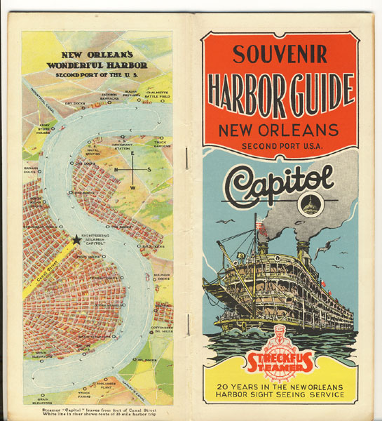
Official New Orleans Harbor Guide And Souvenir Of Steamer Capitol De Luxe
Streckfus Steamers, Inc; Southern Division
Other works by Streckfus Steamers, Inc; Southern DivisionPublication: Streckfus Steamers, Inc,1936, New Orleans
9" x 4" pictorial wrappers. 76pp. including very colorful wrappers. Numerous illustrations, advertisements, map. Streckfus Steamers is the Original and Official Harbor Sight-Seeing Steamer of New Orleans. Much information about the "Port of New Orleans" to include the length, width and depth. "The limits of the Port of New Orleans are defined by Federal Statute..." Seven miles are equipped with wharves, cotton warehouses, grain elevators, et. al. "All owned by the State of Louisiana and operated through the Board of Commissioners of the Port of New Orleans." Also information about railroads, private wharves, elevators and warehouses to name a few. There is berthing space for 90 vessels, 500 feet long; the depth of this area ranges from 30 to 70 feet at the wharf line to 188 feet in midstream. Brief history of the city of New Orleans. It is pointed out that this sight seeing harbor trip is not on the Gulf of Mexico, but on the Mississippi River, smooth water all the way. The main points of interest on the sight seeing harbor trip are listed in the order they appear. Brief descriptions at each point. No. 1 - "Canal Street Excursion Docks;" No. 6 - "Old St. Louis Cathedral;" No. 13 - "Oyster Luggers Landing;" No.29 - "Army Supply Base;" No. 32 - "Galvez Street Wharf;" No. 41 - Ford Motor Company;" No. 55 - "United States Naval Station;" No. 73 - "Crescent Harbor;" No. 88 - "Market Street Docks;" No. 113 - Marine Hospital and Audubon Park;" No. 149 - "The End of the Harbor Trip." Next are facts and figures of New Orleans Harbor to include imports, exports, distances from New Orleans to various parts of the world and to various ports of the world. Briefly describes the Huey P. Long Bridge across the Mississippi River which was completed December 16, 1935. In the center of the booklet is a double page "Key Map of New Orleans" showing locations on the map such as hotels, theaters, restaurants, et. al. Minimal wear to fore-edge of front wrapper else a very good copy, full of information and interesting photos.
Inventory Number: 39866$125.00
Related Books