
Dealer in Rare and First-Edition Books: Western Americana; Mystery, Detective, and Espionage Fiction
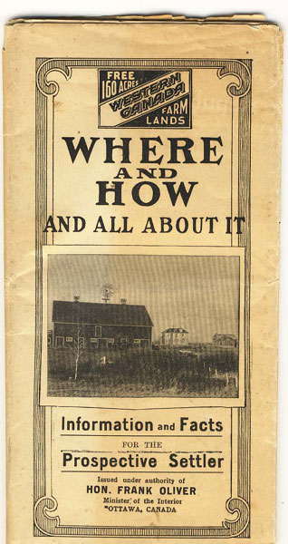
Free 160 Acres Western Canada Farm Lands. Where And How And All About It. Information And Facts For The Prospective Settler
HON FRANK OLIVER
Other works by HON FRANK OLIVERPublication: Privately printed, n d (ca 1905), Ottawa
28" x 21" sheet, one side opens to a color map of Manitoba, Saskatchewan, and part of Alberta, surrounded by 7 margin illustrations: Genboro, Manitoba, a typical western town; Dauphin, Manitoba, showing grain elevators and mills; and 5 pictures of typical Western Canada homes. The other side has 24 panels of illustrations and information. Illustrations include vegetables that will grow in the area, a Western Canada ranch, breaking the prairie with horse drawn plows, etc. A comprehensive section on questions about the area such as: Where are these lands? Are the taxes high? In those parts which are better for cattle and sheep than for grain, what does a man do if he only has 160 acres? Where can he get material for a house and sheds, and about what would it cost him? What does he do for fuel? Do people suffer from the cold? A very informative booklet for the prospective land owner. Cover panels are darkened along the edges, lightly chipped along the edges, one 7" split along one fold, and a bit of light wear to a few fold points, else a good copy.
Inventory Number: 34567Sold -- Contact us
![New Frontiers. Volume I & Volume Ii . GREENBERG, MARTIN H. & BILL PRONZINI [EDITED BY].](/media/images/thumb/10393.jpg)
![Municipal Hand Book Of The City Of Waco. Mayor's Message And Reports Of All Departments Of The City MACKEY, J. H. [MAYOR, CITY OF WACO]](/media/images/thumb/50429.jpg)

