
Dealer in Rare and First-Edition Books: Western Americana; Mystery, Detective, and Espionage Fiction
![The Storied Northwest Along The Northern Pacific Ry / [Title Page] The Storied Northwest. Explored By Lewis And Clark In 1804-6 And Developed By The Northern Pacific Railway Northern Pacific Railway](/media/images/large/46198.jpg)
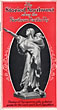
The Storied Northwest Along The Northern Pacific Ry / [Title Page] The Storied Northwest. Explored By Lewis And Clark In 1804-6 And Developed By The Northern Pacific Railway
Northern Pacific Railway
Other works by Northern Pacific RailwayPublication: Privately printed, nd ca 1921, NP
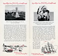
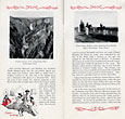
First edition. 7 1/2" x 4" in red and black printed pictorial wrappers with a picture of a statue of Sacagawea on the front wrapper. 20] pp. Illustrations. Map. Overview of the Northwest, its history and the history of the Lewis and Clark Expedition. Black and white photograph on almost every page to include Teakettle Butte, Emigrant Peak, a stagecoach being pulled by 4 horses, the Grand Canyon Custer Indian scouts, Three Forks, Yellowstone, Bridger Canyon, the Columbia River Highway, Mt. Hood, etc. Decorative border in red ink at tops and bottoms of each page. Pictorial illustrations at bottom of several pages.
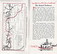
Page 2 offers a map showing the Lewis and Clark Trail and the Northern Pacific Railway route from St. Louis to Portland. Wrappers lightly soiled and with minimal wear to the extremities. Very good.
Inventory Number: 46198Sold -- Contact us
Related Books
![Tombstone's Violent Years, 1880-1882, As Remembered By John Plesent Gray. CARMONY, NEIL B. [EDITED BY].](/media/images/thumb/40183.jpg)
![Legislative History. Arizona 1864 - 1912. KELLY, GEO H. [COMPILED BY].](/media/images/thumb/29010.jpg)

