Dealer in Rare and First-Edition Books: Western Americana; Mystery, Detective, and Espionage Fiction

The Black Hills. A Description Of A Wonderful And Picturesque Mining Region And Natural Sanitarium
PASSENGER DEPARTMENT, CHICAGO & NORTH-WESTERN RAILWAY
Other works by PASSENGER DEPARTMENT, CHICAGO & NORTH-WESTERN RAILWAYPublication: Privately printed, 1905, N P
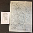
Fourth edition. 8vo. 8 1/2" x 6" original gray, printed wrappers, 50 [2] pp., illustrated from photographs, maps. One black and white map of the North-Western Line, the direct route fro Chicago to the Black Hills. Another map unfolds to 14 3/4" x 21" for the state of South Dakota. Includes a short history of exploration and settlement of the Black Hills, detailed description of the town and health resorts of Hot Springs, and much information on the region's natural resources (particularly mining), railways, and investment opportunities. A small, old water stain along the margin at the top edges but does not affect the text nor the pictures, covers lightly soiled, light wear to the foot of spine, else a very good copy.
Inventory Number: 41699Sold -- Contact us
![Wanderings In The Southwest In 1855 By J. D. B. Stillman. STILLMAN, J. D. B [EDITED WITH AN INTRODUCTION BY RON TYLER]](/static/basic_cms_store2/img/CoverNotFound3.jpg)