Dealer in Rare and First-Edition Books: Western Americana; Mystery, Detective, and Espionage Fiction
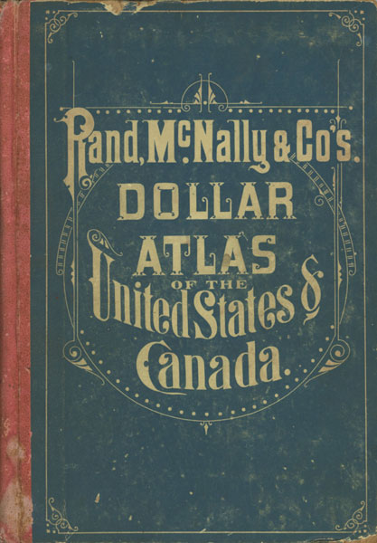

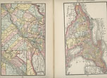
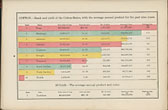
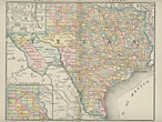
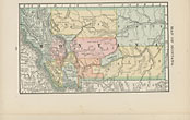
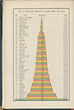
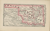
Rand, Mcnally & Co.'S Dollar Atlas Of The United States & Canada / (Title Page) Rand, Mcnally & Co.'S New Dollar Atlas Of The United States And Dominion Of Canada, Containing New Colored Maps Of Each State And Territory In The United States, With Special Maps Of Provinces In The Dominion, Together With Full Descriptive Matter, Relative To The Topography, Climate, History, Population By Sex, Race And Color, Etc., Etc. Graphically Illustrated By Colored Diagrams, Representing The Area In Square Miles And Acres Of States And Territories; Assessed Value Of Property; Railroad Mileage; Cereal Products; Gold, Silver And Currency In The Hands Of The People; Classes Of U.S. Bonds Held By Banks; Registered U.S. Bonds Held By The People, Etc., Etc
Rand, Mcnally & Company
Other works by Rand, Mcnally & CompanyPublication: Rand, McNally & Company, 1884, Chicago
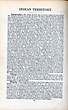
First edition. 10 1/4" x 7 1/4" in quarter red cloth over blue printed boards with white decorative lettering and borders on front and rear covers. 128pp. Contents. Fifteen color diagrams and tables; 54 color maps (several double-page). An informative 19th-Century American atlas, including maps of all the states, and territories in the West, along with many of the Canadian provinces. Diagrams offer information on average yield of corn, wheat, cotton, hay, oats, potatoes, tobacco, and buckwheat. Other diagrams offer information on the assessed value of property; railroad mileage in five divisions; gold, silver and currency in the hands of te people; U.S. bonds held by the people, etc. A color map as well as information offered on each state in the U.S. as well as information on British America and showing a color map for Quebec, Ontario, Nova Scotia, New Brunswick and Manitoba. Last page offers states', territories' and provinces' capitals and populations. The Indian Territory map specifies the Creek, Chickasaw, Choctaw & Cherokee nations, boundaries, with smaller designations for the Cheyenne, Comanche, Kiowa, Apache, Seminole, Ottawattamie, Pawnee & Osage tribes. The Territory of Montana section specifically mentions the recent Custer battle at the Little Big Horn with Chief Sitting Bull, noting the Lakota Sioux finally returned to the U.S. in 1881 and were forced on to reservations. The population statistics for all territories in the West include specifications on numbers of "Colored" which encompassed African American population numbers, Chinese American & Japanese American settlers for each Territory & State in the West. Chinese-Americans at the time were at their high point before the long decline into the 20th Century, and the majority resided in California at over 75,000 the same year the Chinese Exclusion Acts were tightened. Idaho, Washington, New Mexico, Arizona, Utah, & Montana were all still territories as well. Light foxing to endpapers; bumping to corners of covers; minor soiling and with staining to spine. Still a very good sound copy with clean interior and bright maps.
Inventory Number: 47268Sold -- Contact us