Dealer in Rare and First-Edition Books: Western Americana; Mystery, Detective, and Espionage Fiction
![Pleasure Map Of The Lower Rio Grande Valley Of Texas And Mexico WELLS, RUBY [MAP DRAWN BY]](/media/images/large/46882.jpg)
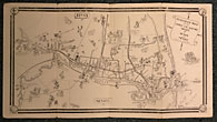
Pleasure Map Of The Lower Rio Grande Valley Of Texas And Mexico
WELLS, RUBY [MAP DRAWN BY]
Other works by WELLS, RUBYPublication: Privately printed for Don Warinner Features, 1935, N P
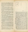
First edition. 23.4 x 43 cm [9 1/4" x 17"] one sheet, folds to 23.4 x 10 .8 cm [9 1/4" x 4 1/4"], four panels per side. One side is a map of the lower Rio Grande of Texas and Mexico. The Texas portion of the map has Padre Island to form one side of the map and Rio Grande City, the Petrified Forest, and Mier form the other side. Points of interest are numbered and include sites in Starr, Hildago, Kenedy, Willacy, and Cameron counties, railroad lines, towns and cities, etc. The Mexico portion features railroad lines, towns such as Matamoros and Reynosa, etc. The other side is four panels that provide brief sketches of thirty locations that are numbered on the map. A portion of one of the panels provided information regarding what to see in McAllen, Texas. Light, overall general wear else a very good copy.
Inventory Number: 46882Sold -- Contact us