Dealer in Rare and First-Edition Books: Western Americana; Mystery, Detective, and Espionage Fiction
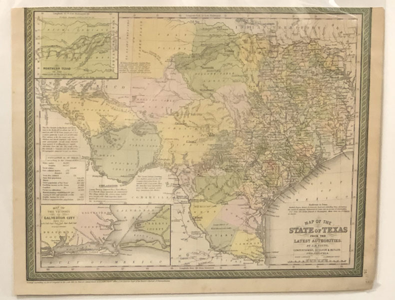
Map Of The State Of Texas From The Latest Authorities, 1850
J. H. YOUNG
Other works by J. H. YOUNGPublication: Cowperthwait Desilver & Butler, 1850, Philadelphia
First edition. 12 1/2" x 16" (overall 13 1/4" x 17"). Ornate green border, hand colored. An atlas map that has been professionally deacidified, flattened and ready for framing. This is one of the most influential atlas maps of its era and the first to reflect Texas’ new boundaries after the Compromise of 1850. By this agreement, for monetary considerations, Texas agreed to relinquish its claims to the upper Rio Grande and Eastern New Mexico. A wonderfully detailed map it shows towns, post offices, trails, wagon roads, railroads (existing and proposed), and the route taken by the Comanches and Apaches on their incursions into Mexico. Descriptive texts discuss the navigability of the Lower Rio Grande and gives population statistics. Insert maps show the city of Galveston and its surroundings as well as the Panhandle of Texas. Top left corner area closely trimmed during removal else a fine bright copy suitable for framing.
Inventory Number: 47096Sold -- Contact us