
Dealer in Rare and First-Edition Books: Western Americana; Mystery, Detective, and Espionage Fiction
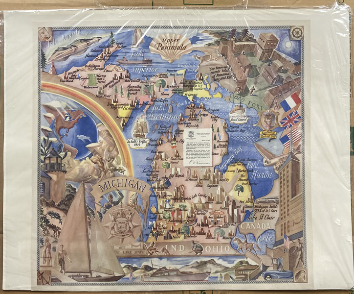
Map Of Michigan And Its Upper Peninsula
STATE OF MICHIGAN
Other works by STATE OF MICHIGANPublication: Privately printed for the State of Michigan, 1940, N P
First edition. Color pictorial 21" x 21 3/4" map of Michigan and the Upper Peninsula, A colorful art deco style map to include the state of Michigan, Lake Huron, Lake Michigan and a portion of Lake Superior. Also detailed are the Straits of Mackinac, Saginaw Bay, Isle Royale, and many cities. A few points made on the map are: "Soo tonnage exceeds total of Panama, Suez and Kiel" and "Michigan builds 90 % of U. S. cars." Fine condition and suitable for framing.
Inventory Number: 49367Sold -- Contact us
![8" X 10 3/4" Typed Letter On The Folding Sawing Machine Co. Inc.'S Stationery, Dated Jan. 10th, 1896 SMITH, FRANK S. [SECY & TREAS]](/media/images/thumb/34744.jpg)
![The Best Of The West. An Anthology Of Classic Writing From The American West. HILLERMAN, TONY [EDITED BY].](/media/images/thumb/49233.jpg)

![The Story Of Manitou HOOPER, S. K. [GENERAL PASSENGER AGENT, DENVER & RIO GRANDE R. R.]](/media/images/thumb/44717.jpg)

