Dealer in Rare and First-Edition Books: Western Americana; Mystery, Detective, and Espionage Fiction
![Joint Maps Of The Northern Boundary Of The United States, From The Lake Of The Woods To The Summit Of The Rocky Mountains. MERRY, L. T. [TOPOGRAPHER]](/media/images/large/48421.jpg)
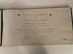
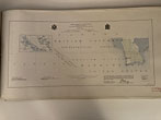
Joint Maps Of The Northern Boundary Of The United States, From The Lake Of The Woods To The Summit Of The Rocky Mountains.
MERRY, L. T. [TOPOGRAPHER]
Other works by MERRY, L. T.Publication: United States Northern Boundary Commission and Her Majesty's North American Boundary Commission, ND Circa 1878, NP Washington ??
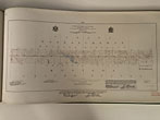
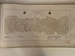
First Edition. Large Oblong Folio. Cloth, 25pp. A series of 24 maps each showing a detailed map of the boundary between the United States and today's Canada. This preceded by a Series Map showing a small scale rendering of the full-page, large maps that follow. This joint effort by the United States and Great Britain is the result of a joint survey conducted in 1876, and is quite rare. The fine lithographed maps detail the region surrounding the forty-ninth parallel. Archibald Campbell was commissioner of the United States organization, while D.R. Cameron headed the British crew. The maps begin in northern Minnesota and run west to the continental divide. Professionally bound for a previous owner, and it appears to have been trimmed slightly at the time of binding. Maps not affected in any way. Ex-library copy with small rubber-stamp imprints in 2 non-obtrusive locations. Binding near fine. Maps show occasional light soiling and slight edgewear to some pages around the edges. The images of the maps themselves near fine.
Inventory Number: 48421Sold -- Contact us