Dealer in Rare and First-Edition Books: Western Americana; Mystery, Detective, and Espionage Fiction
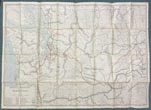
Railroad Commissioners' Map Of Washington 1907.
Washington Railroad Commission
Other works by Washington Railroad CommissionPublication: Rand, McNally & Co, Engravers, 1907, Chicago
34" x 47 1/2" sheet folded to 6" x 8 3/4" featuring a partially colored map of Washington with a legend identifying, with various colored lines, the routes of twenty-five railroads operating and/or under construction in the state. The Pacific Ocean, Puget Sound and rivers are colored blue. Printed on back side is a "Counties and Towns Index to Railroad Commissioners' Map of Washington." The map shows the state of Washington from the Pacific east to just across the Idaho border, and from the northern border with British Columbia south to just beyond the Columbia River and the Oregon state border. It includes town names, county borders, and outlines Indian reservation lands. Railroads shown include Northern Pacific Railway; Washington & Columbia River Railway; Columbia River & Northern Railway; Port Townsend Southern Railroad; Washington, Idaho & Montana Railway; Portland & Seattle Railway (under construction); Great Northern Railway; Spokane Falls & Northern Railway; Columbia & Red Mountain Railway; Washington & Great Northern R’y (under construction); Oregon Railroad & Navigation Co; Ilwaco Railway & Navigation Co; Oregon & Washington Railway (under construction); Columbia & Puget Sound Railroad; Spokane & Inland Railway (electric); Coeur d’Alene & Spokane Railway (electric); Puget Sound Electric Railway; Spokane & British Columbia Railway; North Coast Railway (under construction); Chicago, Milwaukee & St. Paul Railway (under construction); Bellingham Bay & British Columbia Railroad; Tacoma Eastern Railroad; Spokane International Railroad; and North Yakima Valley Railway. The Commissioners of the Washington Railroad Commission in 1907 were H. A. Fairchild, Jesse S. Jones and John C. Lawrence. O. O. Calderhead was the Secretary of the Commission. Several small, closed breaks at intersecting corners else very good plus.
Inventory Number: 51929


